Proposed Hydro Scheme at Ardessie Burn, Allt Airdeasaidh, Wester Ross. Ref. 15/00258/FUL
Objection from the Scottish Wild Land Group
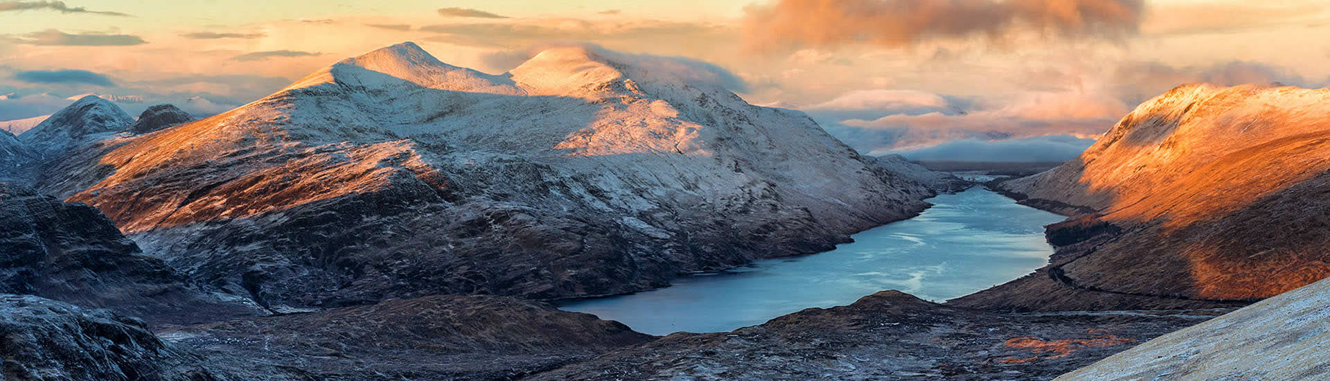
Wester Ross, including the location of the proposed development site, has long been recognised as being of national importance for its landscape. It was recommended to have National Park status by the Ramsay Committee of 1945, and remained a ‘National Park Direction Area’ until the area was designated one of the 40 National Scenic Areas in 1982 owing to its outstanding scenery. Later The Countryside Commission of Scotland in its 1990 report ‘The Mountain Areas of Scotland’ identified the site as being in one of the eight “Most valued mountain cores”.
In the recent work by Scottish Natural Heritage which identified the special qualities of all NSAs, including the Wester Ross NSA, the Ardessie Burn is specifically mentioned: “Burns tend to be rocky, with numerous rapids and falls. Particularly notable are the rocky Little Gruinard River; the cascades of waterfalls on the Ardessie Burn …”
“Great tracts of wild and remote land” has been identified as a special quality of the Wester Ross NSA: “Roads and tracks are few and far between and much of the mountain landscape is renowned for being wild and remote, with a natural vegetation cover and few, if any, buildings or structures. Wild areas can be far distant from any road, only accessible by long walks on foot.
“The grandeur of the mountains and the great hidden lochs that can be found between them, together with the wild, unpredictable weather, makes a visit to these remote areas particularly memorable.
“However, wildness can also be found in many of the more accessible areas [emphasis added], whether along a stretch of undeveloped coast, a short walk into rocky moorland, or even beside the road where it traverses the mountain interior.”
Note that the ‘wildness’ special quality is not confined to the remote areas – see the emphasised text above. However the upper end of the proposed site lies within an area of ‘high wildness’ as assessed by SNH in their wild land mapping. Indeed much of the proposed development is within one of SNH’s recently identified core Wild Land Areas. For these areas, the Government’s National Planning Framework states: “We also want to continue our strong protection for our wildest landscapes – wild land is a nationally important asset.”
By definition, an area is defined as wild if human infrastructure is absent. Hence any addition of infrastructure, whether dam, pipe, hard-standing or track will reduce the wildness: mitigation is not possible.
Considering the above recognition of the national scenic importance of the area and that the development is in a Wild Land Area, it is surprising that a developer is even considering putting forward such a proposal. If it is allowed to go ahead, it rather makes a nonsense of any attempts to protect Scotland’s finest scenery, devaluing the work of the Ramsay Committee and all the subsequent work. National Scenic Areas are nationally important by virtue of the landscape qualities that make them special – their ‘special qualities’. There seems little point in having NSAs if their identified special qualities are so easily cast aside by developers.
The proposed development will introduce a constructed track up to nearly 300m altitude, which will be widely visible from many places, as recognised by the developer. The argument given that the proposed track will only be formalising an existing vehicle route is specious: because landscape damage is being created, it does not logically follow that the answer is to introduce a constructed route with a greater visual footprint. If landscape damage is currently being done within an NSA or wild land area, then means must be found to reduce the damage.
The incredibly poor quality of the landscape reinstatement following the recent construction of the Boor Burn run-of-river scheme on Loch Ewe (within the same NSA), gives no confidence that restoration here will be any more successful, or best practice followed. Additionally, the creation of disturbed ground up to nearly 300m altitude will encourage into the SSSI plants which are not normally found there such as gorse (as is happening at the Boor Burn site).
Finally, the waterfalls of the Ardessie Burns provide one of the finest spectacles for the walker in Scotland. Rivers in this part of the world tend to be spate rivers, rising and falling quickly. This means that during dry spells the burn will be relatively empty, and any extraction of water will significantly diminish the spectacle of the waterfalls.
Hence the Scottish Wild Land Group objects to this proposal in the strongest possible terms. If allowed to proceed, it sends a clear message that the people of Scotland care little about their finest landscapes and that no area is sacrosanct.